#NotJoaquin’s coastal flooding plagues mid-Atlantic
Tidewatch system records minor flooding of unusual duration
It wasn’t a hurricane—with #NotJoaquin trending on Twitter—and not exactly a nor’easter, but the windy, rainy weather that plagued the U.S. East Coast during the last week generated coastal flooding in Tidewater Virginia whose magnitude compares to that of several previous named storms, and whose longevity may set a local record.
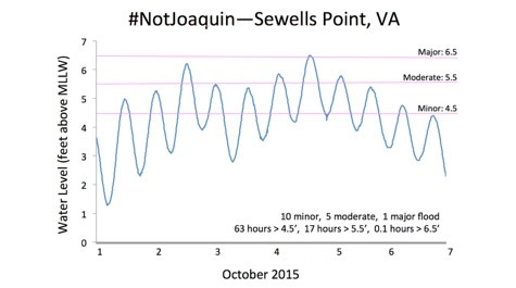
Emeritus professor John Boon of the Virginia Institute of Marine Science reports—based on data from VIMS’ Tidewatch network—that water levels during high tide at Sewells Point exceeded NOAA’s designated level for minor coastal flooding for more than five straight days—from Thursday morning, October 1st through Tuesday morning October 6th.
Sewells Point—at Naval Station Norfolk—is one of NOAA’s longest-running Chesapeake Bay tide gauges and 1 of 10 tidal stations in VIMS’ Tidewatch network. The Tidewatch stations record the difference between predicted astronomical tides and observed water levels in Chesapeake Bay and up Virginia’s Eastern Shore, providing an effective way to measure, visualize, and forecast the magnitude and impacts of coastal flooding. The data are particularly useful for comparing storm tides in areas with different tidal ranges.
By Boon’s calculation, the water at Sewells Point during the recent stormy weather exceeded NOAA’s designated minor flood level (4.5 feet above mean lower low water) during 10 consecutive high tides, including 5 high tides with waters above the moderate flood level (5.5’ above MLLW) and one episode of major flooding—when water levels peaked at 6.5’ above MLLW on the afternoon of Sunday, October 4th.
All told, that equals 63 hours of at least minor coastal flooding. Water levels reached the moderate flood stage during 17 of those hours, and entered major flooding territory for a few minutes on either side of Sunday’s 3:14 pm high tide.
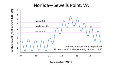
Boon says the most similar recent storm would be Nor’Ida, a nor’easter that developed from the remnants of Hurricane Ida in November 2009. It produced a higher peak storm tide—7.75 feet above MLLW—but its period of minor coastal flooding was slightly less.
Tidewatch shows that Nor’Ida brought 55 hours of minor coastal flooding to Sewells Point (through 7 high-tide cycles), including 33 hours of moderate flooding (5 high-tide cycles) and 13 hours of major flooding, separated into 3 consecutive high-tide cycles with a peak of 7.75 feet above MLLW on November 12th.
Boon says the extended duration of coastal flooding during #NotJoaquin and Nor’Ida can be partly explained by their similar development as extratropical low-pressure systems associated with a tropical cyclone. Extratropical lows can stall near Virginia, whereas hurricanes or other tropical cyclones typically speed up as they move northward from their low-latitude breeding grounds. One example is Hurricane Isabel, which made landfall in the mid-Atlantic in September 2003. Isabel’s impacts on Virginia were intense but short-lived, with its record-setting storm surge restricted to a single high-tide cycle. Isabel’s storm surge peaked at 7.9 feet above MLLW at Sewells Point on September 18th, 2003.
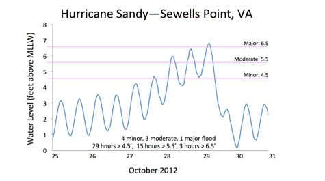
Hurricane Sandy—with some extratropical characteristics—fell between the extremes of Isabel and #NotJoaquin. It produced 29 hours of at least minor coastal flooding at Sewells Point (through 4 high-tide cycles), including 15 hours of moderate coastal flooding (3 high-tide cycles) and 3 hours of major flooding when water levels peaked at 6.8 feet above MLLW around the morning high tide on October 29th, 2012.
Boon points out that #NotJoaquin’s influence is just one component of an even lengthier period of high water that began affecting the mid-Atlantic around mid-September. Data from Tidewatch show that observed tides exceeded the predicted astronomical tide—however slightly—during 13 consecutive high-tide cycles beginning on September 15th. The direct cause of elevated water throughout the recent weeks is a persistent northeasterly wind, which acts to drive coastal waters into Chesapeake Bay and its tributaries.
VIMS escapes damage
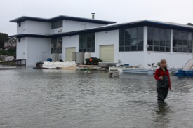
Despite the prolonged inundation of Gloucester Point during #NotJoaquin, VIMS suffered little or no flood damage. Marine superintendent Durand Ward reported 14 inches of water in VIMS’ Trailer Repair Shop and 2 inches in the Marine Safety Office/Dive Locker, while algae specialist Amanda Chesler says there was little water in and no damage to the VIMS Oyster Hatchery.
 Joe Martinez, VIMS Chief Operations Officer, says that VIMS' Seawater pier and Vessels Operation Center emerged unscathed. The structures, designed to replace the VIMS Ferry Pier and older buildings in the VIMS Boat Basin after they were damaged during previous storms, were purposefully elevated to minimize storm-related damage. The concrete pier's deck stands 13 feet above sea level. The Vessels Operation Center was built on a foundation that is raised 10 feet above sea level.
Martinez says the improvements “provided significant savings to the Commonwealth.” He also thanks VIMS’ facilities crews for their hard work—including emplacement of storm shutters on Watermen’s Hall and transport of nearly 20 smaller vessels to high ground—in preparing the campus for potential impacts.
Richard Snyder, Director of VIMS Eastern Shore Laboratory in Wachapreague, says the ESL’s new seawater facility and Seaside Hall stayed dry as designed. Tidewatch shows that water levels at the lab peaked at 7.66 feet above MLLW during the afternoon high tide on Friday, October 2nd.
There are no reports or expectations that prolonged inundation by #NotJoaquin significantly affected marine or marsh life in Chesapeake Bay. VIMS researchers will continue to analyze the storm’s characteristics and potential impacts as they retrieve data from field instruments and perform needed quality control.


