Tidewatch forecasts go public
Predictions will help Bay-area residents better prepare for coastal flooding
Researchers at the Virginia Institute of Marine Science have added forecast capabilities to their network of Tidewatch water-level stations, giving residents of the lower Chesapeake Bay region a new on-line tool for gauging the magnitude of coastal flooding in a given location and minimizing its potential impacts.
The public launch of the Tidewatch forecast system (vims.edu/tidewatch) comes just in time for the height of the Atlantic hurricane season, which typically peaks on September 10. A string of hurricanes and strong nor’easters during recent years, coupled with rising sea level, have brought several episodes of significant flooding to Tidewater Virginia and other areas of the Bay.
Emeritus professor John Boon, lead developer of the Tidewatch system, says the forecasts will provide concerned citizens with “timely guidance on what the time and height of the next three high waters are expected to be.” He adds “They can use that information to prepare for coastal flooding, whether that involves gathering sand bags, moving possessions to higher ground, adjusting mooring lines for their boat, or choosing an evacuation route.”
VIMS Dean and Director John Wells calls the Tidewatch forecast system “an outstanding example of translating the results of research into products that benefit the citizens of the Commonwealth.”
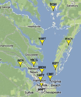
The Tidewatch system now generates 36-hour public forecasts for 9 water-level stations within Chesapeake Bay and a single station on Virginia’s seaside Eastern Shore. The forecasts, updated every half hour, were previously only available on an experimental basis.
Testing and Refinement
Boon and his colleagues at VIMS—associate professor John Brubaker and assistant research scientist David Forrest—decided to make the forecasts available to the public after testing and refinements increased their confidence in the forecasts’ accuracy.
 “We worked with Virginia Sea Grant, the National Weather Service, emergency managers, and selected
waterfront property owners to test and
refine the system over the last three years,” says Boon. “Now we think
it’s good to go.”
Their testing included performance checks in real-time during Hurricane Irene, tropical storm Ernesto, and the November 2009 nor’easter, as well as “hindcasts” made by feeding data from 2003—the year of Hurricane Isabel—into their prediction model. The average expected error for the Tidewatch forecasts is now about 3.5 inches at 36 hours forward in time, and about 2.5 inches at 12 hours. However, during a tropical storm or hurricane the error can be several times as large due to rapidly changing wind speed and direction. The potential for large errors is offset by half-hourly updates made with the latest observed water levels.
m30 and the Residual
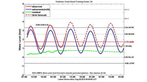
Boon, Brubaker, and Forrest developed the Tidewatch forecasts in close partnership with National Weather Service researchers at NOAA headquarters in Silver Spring, Maryland, and in the regional NWS office in Wakefield, Virginia. Indeed, output from NOAA’s SLOSH model—the official instrument for forecasting “Sea, Lake, and Overland Surges from Hurricanes”—is one of the three components of the Tidewatch forecasts. The second is the predicted astronomical tide—the high and low water levels forecast in the familiar daily tidal charts.
What sets the Tidewatch forecasts apart, says Boon, is its third component: inclusion of a 30-day running average of the observed water level denoted as m30. When m30 is added to the predicted tide and their sum subtracted from the observed water level, a difference that meteorologists and oceanographers call the “residual” results, viewed in Tidewatch through a moving 30-day window. Changes in the size and sign of the residual produce what Boon terms the “sub-tidal oscillation,” which Tidewatch shows in near-real time.
“The sub-tidal oscillation is caused mainly by the movement of weather fronts through our area,” says Boon. “We here in the mid-latitudes typically get a frontal system moving through every 4 to 5 days or so, depending on the season, with resulting changes in wind speed, wind direction, and atmospheric pressure.” These meteorological changes affect sea level, producing rhythmic increases and decreases in water levels that are largely independent of an approaching hurricane or nor’easter.
“You can think of these ups and downs as the ‘weather tide’,” says Boon, “with the changing winds that follow the passage of each front tending to move water around inside and outside the Bay. We certainly see that in the residuals.” When a major storm visits the area, he says, “the rise in water level due to the ‘storm surge’ can cause the residual to grow quite large.”
In addition to depicting sub-tidal oscillations and storm surge, m30 also accounts for water-level change occurring at much longer periods spanning months, years, and decades. These changes include so-called “sea-level anomalies” that happen every few years, as well as ongoing sea-level rise relative to the land. “If we didn’t use m30”, says Boon, “long-term variations in sea level would be folded into the residual and become indistinguishable from storm surge and the sub-tidal oscillation.”
"Extratidal" Water
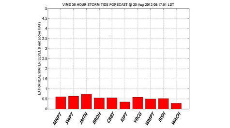
Tidewatch is also unique in referencing the height of storm tides to the “highest astronomic tide.” This value, abbreviated in Tidewatch as “HAT83,” is the highest predicted tidal level in the current version of the tide tables for a given location. The “83” refers to 1983, the initial year of the 19-year interval (1983-2001) that NOAA currently uses as a baseline for its official tide tables. (This baseline, the “National Tidal Datum Epoch,” is periodically updated as required to account for the ongoing change in sea level observed at U.S. tide stations.)
Comparing extreme water levels to HAT, says Boon, best indicates how storm tides will affect coastal residents, as it provides a natural benchmark that people have used to site waterfront structures such as docks, boathouses, and dwellings.
"Points just above HAT fall within a zone that appears dry most of the time,” says Boon. “Coastal residents therefore tend to use that land, adding infrastructure that enhances its monetary value and encourages its use. A Tidewatch forecast that calls for water levels to exceed the HAT line—what we call ‘extratidal’ water—is thus of special concern, as those conditions are likely to affect vulnerable property.”
Boon says another benefit of referencing storm tides to HAT is that doing so removes the effect of tidal range—an independent factor that varies from place to place. “Only extratidal high water is a true index of flooding severity at two locations with different tidal ranges,” he says.
Boon will explore the public launch of the Tidewatch forecast system during VIMS’ After Hours Lecture on Thursday, August 23rd. The lecture begins at 7:00 pm and takes place in Watermen’s Hall on the VIMS campus in Gloucester Point. Visit https://events.wm.edu/event/view/vims/9580 to register online.


