Current Prediction
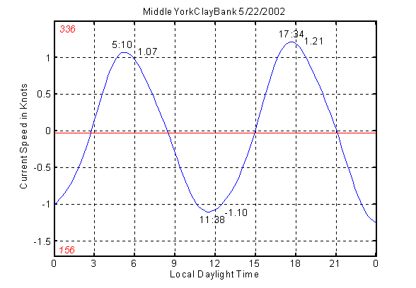
Reversing Currents - In making water current predictions, a tidal current model based on HAMELS (Harmonic Analysis, Method of Least Squares) follows the same one-dimensional approach used in current analysis. It typically predicts only the component of flow along the principal horizontal axis, the directional axis containing the maximum observed variance in current speed. In places where the current is mostly bi-directional, or reversing, one dimension is sufficient and the method works quite well. Here’s an example of a HAMELS current prediction for the surface layer of the Middle York River opposite Clay Bank, Virginia:

At Clay Bank, the flood surface current flows mostly toward the north-northwest at a heading of 336º while the ebb surface current flows mostly toward the south-southeast at 156º. These are the principal axis headings for the surface layer at this station.
By convention, flood current speeds are shown as positive numbers and ebb current speeds are shown as negative numbers on the speed scale.
Whenever the current is represented by a single dimension as in the case above, a current curve (blue line) results that has exactly the same appearance as a normal tide curve (see tide prediction module). Two peak floods and two peak ebbs are predicted just as two high waters and two low waters are predicted each day in a region where tides are of the semidiurnal type. Currents are a little different in that slack water is predicted to occur whenever the blue curve crosses the zero current line. The red horizontal line in the above figure represents the mean current during the period of analysis (14 days in this instance) – the current that presumably would still be there if there were no tide and no tidal current. It’s normal to find a slightly negative mean current heading seaward in the surface layer of a partially mixed river estuary like the York. In contrast, the mean current in the bottom layer is usually landward when classical, two-layer circulation prevails.
In other locations where currents are no longer bi-directional but show a lot of movement in other directions, the principal axis may not tell the whole story - a secondary axis at right angles to the principal axis may contain a lesser but still significant amount of the total variance in a two-dimensional (U,V) data set. In addition to the principal axis, it’s possible to simultaneously predict current along the secondary axis as well. A special statistic (the reduction in variance achieved by the tidal current model) helps to determine whether this is worthwhile. In the event that it is, Up and Vp – the principal and secondary flow components – can be combined to give predicted current speed and direction at fixed intervals of time. The result is a rotary current prediction.
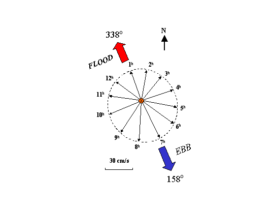
Rotary Currents - NOAA/NOS current predictions use a current speed and direction format at a limited number of selected offshore stations that exhibit typical rotary current behavior. Rotary currents never become slack and continually change their direction (turning clockwise or anti-clockwise) through all points of the compass (see Table 5, NOS Tidal Current Tables). Here’s an example of a rotary current diagram compiled from VIMS current measurements made near the bottom at Thimble Shoal Light in lower Chesapeake Bay.
 Times for these currents are usually expressed in hours
following maximum flood at a nearby reference station where currents are of the
reversing type and are predicted daily (Table 1, NOS Tidal Current Tables).
The majority of NOS current prediction stations are, in fact, of the reversing type and utilize time differences and speed ratios (Table 2, NOS Tidal Current Tables) to correct the daily predictions made at reference stations (Table 1) so that they apply at a local station. Similar to the NOS Tide Tables, the user must perform the necessary additions and multiplications to get times and speeds for the maximum currents (flood or ebb) and minimum currents (before flood or ebb) for any day of the year.
Not-quite Reversing Currents - Although the majority of NOAA/NOS current predictions are made at stations described as having reversing currents, the directions listed for maximum flood and maximum ebb frequently differ by a little more or a little less than 180 degrees. In some cases, the strongest currents occur at headings determined by the local bottom topography (water in motion tends to “remember” the topography behind rather than ahead of it). Quite often, in a bend in a channel for example, these are not reciprocal headings.
Working up a Current Prediction from NOS Tables - Here’s an example of the information you would need to obtain an NOS current prediction for a local station. Let’s try Clay Bank, Virginia, on May 22, 2002, so we can compare the result with the HAMELS prediction for this station. Looking up Clay Bank in NOS Current Table 2, the following entry is found:
|
PLACE |
POSITION |
TIME DIFFERENCES |
SPEED RATIOS |
AVERAGE FLOOD |
AVERAGE EBB |
|
Clay Bank |
37º20.78’N |
Min. Flood Min. Ebb |
Flood Ebb |
Max. Speed Dir. |
Max. Speed Dir |
|
Pier* |
76º36.80’W |
-02m +14m +1h17m -05m |
1.4 0.9 |
1.1 knots 311º |
1.1 knots 123º |
*100 yards southwest of
These numbers apply to a reference station at the Chesapeake Bay Entrance in Table 1 where the entry for May 22, 2002, looks like this:
|
Date |
Slack |
Maximum |
|
22 |
0134 |
0403 0.8F |
|
W |
0705 |
1055 1.4E |
|
|
1402 |
1649 1.1F |
|
|
2012 |
2332 1.4 |
Now if we want the late afternoon maximum current at Clay Bank, we add 14 minutes to 1649 to get the time for the maximum flood at1703 Local Standard Time (1803 Local Daylight Time), and multiply 1.1 times 1.4 to get 1.5 knots, the predicted speed of the flood current. The slack (minimum) before this flood is predicted to occur at 1402 minus 2 minutes or 1400 LST (1500 LDT). Comparing the NOS prediction against the blue HAMELS curve, we see that HAMELS under predicts the time and the magnitude of the selected flood although times for the slack before the flood agree perfectly.
HAMELS vs. NOAA/NOS – In contrast to the NOS current predictions with their non-reciprocal headings, harmonic analysis and the harmonic constants it derives works on only one set of reciprocal headings (one principal axis) at a time. In fact, a current curve like the one shown for Clay Bank at the top of the page can only be drawn using reciprocal headings. This is one reason why it is difficult to compare such predictions with the NOS current predictions. The other reason is that currents measured only a slight distance apart in seaways with channels can be quite different. The VIMS ADM current meter used in the HAMELS analysis was installed between March and April 2002, in the secondary channel near the south side of the river across from Clay Bank. The NOS instrument was located on the north side of the river near a pier according to the information in Table 2. We also do not know the date of the NOS current measurements made at Clay Bank, a factor that may be quite important in a tidal tributary later modified by dredging.
With the exception of its rotary current predictions and the prediction of slack water or minimum reversing currents, NOAA/NOS predictions clearly concentrate on the speed and direction of the peak currents in every current cycle, pretty much ignoring the rest of the current field or leaving it to the user to approximate. Since the strongest currents – like the highest or the lowest tides in a day – represent the biggest concern for vessels navigating in restricted waters, you can see why this gets the most emphasis in light of federal mandates for marine safety. But from a scientific point of view, the rest of the current field matters. For example, simulated time histories of current speed and direction are frequently combined with suspended solids concentration in order to model the transport of waterborne materials in estuarine systems. In this type of work it is important to avoid adding bias to the numbers, including those added as safety factors.
Quality of Current Predictions – How Good is Good?
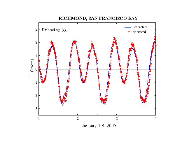
There are many ways to look for the answer to this question. One approach is to compile statistics based on a comparison of a large number of predicted currents with the actual currents that occurred. This approach might tell us, for example, that the actual times of slack water or maximum current differ from predicted times by a half hour or less ninety percent of the time. Another approach is to compare detailed current predictions with independent data from historical records at a well-maintained current station - data other than the original series of measurements used to obtain the tidal harmonic constants. Rather than just the extremes, it’s worth taking a close look at the entire current curve to see what agrees and what doesn’t. A few days of surface current record from the NOS station at Richmond in San Francisco Bay provides a good example.

As the above comparison shows, most of the “limbs” of the HAMELS predicted current (blue curve) agree very well with the NOS current observations (red crosses). However, when we look closely at the observed current peaks, it’s clear that the readings are not always steady or varying smoothly. At the times of the peak flood current, there are sporadic “spikes” where a few current readings suddenly stand out on the high side. During the peak ebb, on the other hand, many of the current readings seem to weaken and oscillate back and forth. Whether this behavior is a natural part of the current regime – or whether it’s related to the response of the instrumentation – is difficult to know for certain. In other words, it’s difficult to say how good is good until we understand what we’ve measured. But strictly speaking, harmonically predicted tidal currents can only produce a smooth curve, not a jittery one. The least squares approach to fitting this part of the data is generally the preferred one.
