
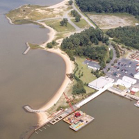
(EUS) Fort Eustis
Location:
James River, City of Newport News, Virginia
Site Parameters
- Coast Type: Embayed
- Body of Water: James River
- Shore Direction of Face: NA
- Shore Type: Marsh/Beach
- Average Shore Height: 5 feet
- Average Fetch: 3.5556 nautical mile
- Distance to 6ft Contour: 833 feet
- Type: Headland Control
- Number of Breakwaters: 3
- Number for Bays: 2
Land Use: Military
Ownership: U.S. Army
Problem: Shore erosion of Ft. Eustis Training Shore also known as "Anzio Beach"
Purpose: Shore protection
This project was designed by U.S. Army Corps of Engineers, Norfolk District and VIMS using primarily shoreline geomophology as a measure of dominant wave approach. Installed in 1995, the system armored existing headland features (old landing craft) with stone and built an additional headland breakwater and large spur to enhance/create large stable pocket beaches. An area of low elevation was left in existing headland to preserve an intertidal marsh.