
(MUR) Murphy, Tayloe
Location:
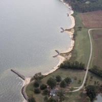
Potomac River, Westmoreland County, Virginia
Site Parameters
- Coast Type: Straight
- Body of Water: Potomac River
- Shore Direction of Face: NE
- Shore Type: High Bank
- Average Shore Height: 15 feet
- Average Fetch: 6 nautical mile
- Distance to 6ft Contour: 1013 feet
- Date Installed: September 1997
- Type: Headland Control
- Number of Breakwaters: 3
- Number of Bays: 2
Land Use: Agriculture
Ownership: Private
Problem: Chronic erosion of 15 ft upland bank
Purpose: Long-term shore erosion control
This site is a working farm that has a long fetch to southeast of over 20 miles. Funding restraints and positive results of VIMS' study of the Hog Island Headland and Summerille sites led to the installation of a 1,700 ft headland control system in 1995. Three widely spaced headland breakwaters were constructed and one large spur/breakwater upriver was used to set the embayment. The headland control method consists of breakwaters that are placed close to shore to insure long-term connection and the adjacent upland banks are allowed to erode to equilibrium. The project was designed utilizing shore morphology evolution.