
(SUM) Summerille
Location::
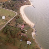
Potomac River, Northumberland County, Virginia
Site Parameters:
- Coast Type: Embayed
- Body of Water : Potomac River
- Shore Direction of Face: North East
- Shore Type: Low Bank
- Average Shore Height: 10 feet
- Average Fetch: 10 nautical mile
- Distance to 6ft Contour: 750 feet
- Type: Headland Control
- Number of Breakwaters: 2
- Number of Bays: 1
Land Use: Old Farm
Ownership: Privately owned
Problem: Severe erosion of 12 ft upland bank
(10 ft/yr).
Project purpose: Long-term shore erosion control and demonstration project
Shore morphology is a classic case study that has been researched by VIMS and Corps. The site has a long fetch to east of over 20 miles. The project covers 1,200 ft of shoreline with a spur installed as the first phase in 1978. In 1992, a revetment was built on the downdrift side of the bay and the spur rebuilt; in 1997, large spur breakwaters were constructed off the revetment to set the tangential beach and perch the sand into the bay. The project has long-term management implications by enhancing existing shore features to create headlands and pocket beaches. The bay has recently evolved into static equilibrium over a period of 20 years.