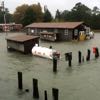
Windy weather generates coastal flooding whose longevity may set a local record.

Windy weather generates coastal flooding whose longevity may set a local record.
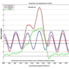
Sandy brings unusually persistent high-water levels to Virginia.

Irene brings 4.4 feet of extra-tidal water to Money Point
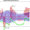
A mid-March nor'easter brings 1.46 feet of extratidal high water (XBH) to Windmill Point.
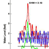
A mid-December nor'easter brings 2.87 feet of extratidal high water to Money Point.
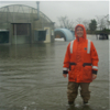
A significant coastal-flooding event occurs along the mid-Atlantic coast as a low-pressure remnant from Tropical Depression Ida travels up the Atlantic seaboard. The storm brings 4.69 feet of extratidal high water (XHW) to Money Point.

A nor'easter brings 1.26 feet of extratidal high water to the Yorktown Coast Guard Training Center.
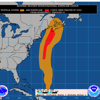
A disturbance related to Hurricane Kyle affected lower Chesapeake Bay in late September 2008, bringing 2 feet of extratidal high water to the Chesapeake Bay Bridge Tunnel.
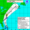
Tropical Storm Hanna moved over lower Chesapeake Bay in early September 2008, bringing 0.55 ft of extratidal high water to the Tidewatch station in Yorktown.
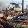
Hurricane Isabel impacted the mid-Atlantic between September 17-19, 2003. Isabel predates the Tidewatch network but merits mention as one of the most intense storms to strike the region in recent memory.